Talks

2024

Intercomparing Surface Water Extent Mapping Products and Packages

Satellite Earth Observations (EO) have long proven to be a powerful tool for observing floods given their ability to cover large geographic areas where ground-based observations are lacking. There is a wealth of literature demonstrating various techniques for satellite-based surface water extent mapping for flood applications on both optical and Synthetic Aperture Radar (SAR) sensors, but users struggle to apply different techniques and discern which are most appropriate for unique contexts. To mitigate these challenges, many organizations have recently created global analysis-ready water map products, while others create customizable software that users can tailor and apply to their region of interest. Given the range of surface water mapping products and software packages available, it is imperative for the scientific community to precisely communicate to end users the accuracies, uncertainties, and assumptions underpinning these products. Without such communication, end users seeking to apply EO for flood early action and risk reduction will be oversaturated with surface water mapping products and software that may yield conflicting results. SERVIR – a joint initiative of NASA, USAID, and geospatial organizations in Asia, Africa, and Latin America – co-develops regionally tailored services to inform specific decisions and early actions. To address a growing need across the SERVIR network to understand the performance of open-source satellite-based surface water extent data products and software for inland flood applications, SERVIR is conducting a flood mapping intercomparison project. This presentation introduces the project, presents preliminary results, and discusses the tradeoffs, strengths, and weaknesses of the sensor characteristics (e.g., spectral, temporal, and spatial resolution) and methodologies associated with each product/package. The desired outcome of this intercomparison is clarity to decision-makers and scientists alike regarding the strengths and weaknesses of many different surface water extent mapping products/software in several decision-making contexts. We anticipate the results from this study will improve the understanding surrounding the use of EO for flood early action and risk reduction.
December 13, 2024

American Geophysical Union (AGU) Fall Meeting / Washington DC


Conference website

Economic Impact Assessments (EIA) of application of GEOGLOWS in Ecuador- Data Gaps, Limitations and Recommendations

In 2022, the United Nations launched the Early Warnings for All (EW4ALL) Program to establish global early warning systems by 2027. To assess the impact of the substantial $3.1 billion annual investment over five years, EW4ALL will consider factors that will require national coordination for the data needed for these assessments. In 2023, Ecuador was identified as one of the world’s most climate-vulnerable countries, emphasizing the need to enhance its early warning systems. In 2020, the SERVIR Amazonia hub implemented the GEOGLOWS streamflow forecast service in collaboration with Ecuador’s national meteorological agency (INAMHI). GEOGloWS provides 15-day ensemble forecasts and 80 years of historical streamflow data for every river worldwide through a free web service. The World Meteorological Organization has recognized this initiative as essential in contributing to the UN’s call to ensure an ‘Early Warning for All’ by 2027. In 2023, as part of NASA’s continuous efforts to fund research for Policy-Relevant Implementations, an economic impact assessment (EIA) was performed to understand the potential socioeconomic benefits of Early streamflow predictions in Ecuador using the GEOGLOWS service. Preliminary findings highlighted that gaps remain in effectively integrating socioeconomic and Earth observation (EO) data to capture the total value of these predictions. Implementing GEOGLOWS has led to valuable hydrological forecasts; however, the total economic benefits have yet to be documented. This study addresses the gaps and makes recommendations for future work that should focus on capturing the socio-economic benefits and costs associated with these forecasts, including their impact on decision-making at national and local levels. Despite the daily use of GEOGLOWS by key figures, including the President of Ecuador, the need for comprehensive recommendations and assessments is urgent.

December 12, 2024

American Geophysical Union (AGU) Fall Meeting / Washington DC


Conference website

ClimateSERV - Lowering the Barrier to Integrating Earth Observation Climate Data into Decision Making

Incorporating earth observation (EO) data into decisions can be a challenging process. It requires not only the technical and computational capacity to analyze and interpret the data but also the ability to integrate this information effectively into a decision making framework. Understanding the needs of the users and capacity building plays a crucial role in equipping stakeholders and decision-makers with the necessary skills and knowledge to utilize these advanced datasets and tools. The lack of robust, high-speed communication infrastructure further exacerbates this challenge in many countries. Overcoming obstacles related to limited access to reliable internet and data services is a prerequisite to advancing the use of remote sensing tools and the timely dissemination of critical information. Seeking to address these limitations the SERVIR program developed ClimateSERV. ClimateSERV provides user-friendly access to visualize, analyze, and download climate data with minimal bandwidth requirements and faster, server-side processing. Examples of ClimateSERV usage include improved lead time and accuracy of flood warnings in the lower Mekong region, providing seasonal outlooks to farmers for planning planting times and crop cultivars in Kenya, and supporting crop insurance in Africa. Here we present how providing access to EO- derived climate data through a user-needs centric approach coupled with capacity building can enhance decision making and provide broad scale impacts.

December 12, 2024

American Geophysical Union (AGU) Fall Meeting / Washington DC


Conference website

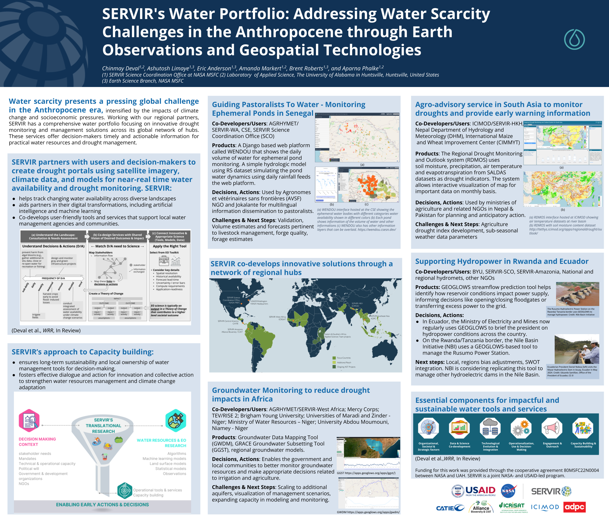
SERVIR’s Water Portfolio - Addressing Water Scarcity Challenges in the Anthropocene through Earth Observations and Geospatial Technologies

Water scarcity presents a pressing global challenge in the Anthropocene era, intensified by the impacts of climate change and socioeconomic pressures. Working with our regional partners, SERVIR has a comprehensive water portfolio focusing on innovative drought monitoring and management solutions across its global network of hubs. SERVIR worked with users in the region to understand decision-makers needs to collaboratively develop drought portals, which integrate satellite imagery, climate data, environmental data, and hydrological models to provide near real-time monitoring and forecasting of water availability and drought conditions. These portals offer decision-makers timely and actionable information for practical water resources and drought management. The presentation explores how SERVIR helps track changing water availability across diverse landscapes, from ephemeral water bodies in Senegal to groundwater resources in Niger to drought outlooks in South/Southeast Asia. We demonstrate the transformation of these digital innovations, including artificial intelligence and machine learning, into user-friendly tools and services that support local water management agencies and communities. Additionally, we discuss the impacts of changing water availability on populations, highlighting efforts to assess and mitigate these effects in agriculture, ecosystem management, and reservoir water management. Capacity building is a crucial aspect of SERVIR efforts. This presentation illustrates our approach to ensuring long-term sustainability and local ownership of water management tools for decision-making. SERVIR aims to foster effective dialogue and action for innovation and collective action to strengthen water resources management and climate change adaptation in SERVIR regions.

December 11, 2024

American Geophysical Union (AGU) Fall Meeting / Washington DC


Conference website

Evaluation of Potential Environmental Drivers of Algal Blooms in Central American Crater Lakes

Recent global studies indicate that rising temperatures may be fueling the proliferation of algal blooms in lacustrine systems. In Central America, recurring algal blooms in endorheic lakes have appeared only within the last fifteen years. Mirroring a similar situation occurring in Lake Atitlan in neighboring Guatemala, El Salvador’s Lake Coatepeque - a 26 km2 volcanic crater lake - is one such system whose recent (c. 2020) algal blooms have raised concerns among local authorities due to the Lake’s importance to the economies of nearby communities. The Lake’s algal blooms - which at times occupy up to a third of the water’s surface - are also apparent in the satellite imagery. We compiled Earth observation data from 2003-2024 to evaluate trends and potential drivers, including daytime and nighttime water surface temperature, incident radiation, precipitation, and the normalized difference vegetation index for the surrounding watershed which drains into Lake Coatepeque. Chlorophyll a concentrations and estimates of water turbidity were also extracted from the satellite data record. Preliminary analysis suggests that various environmental factors might be at play in triggering the algal blooms. The water surface temperature has been shown to increase over the last ten years, in tandem with increases in long-wave incident radiation and the concentrations of photosynthetic pigments. This work analyzes long-term trends on water temperature, algal bloom presence, precipitation, runoff and land cover changes to identify the main potential drivers of algal blooms in these crater lakes. Given the similarities between the proliferation of algal blooms in Lake Coatepeque and Lake Atitlan, the NASA/ USAID SERVIR program aims to apply an analogous predictive model successfully implemented for the latter to help local decision-makers in monitoring efforts by identifying when algal blooms are likely to occur in Lake Coatepeque.

December 11, 2024

American Geophysical Union (AGU) Fall Meeting / Washington DC


Conference website